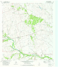
1982 Map of Weir
USGS Topo · Published 1982About this map
Walburg and Weir anchor this central Williamson County landscape, where agricultural tradition and early transportation networks converge. The Missouri Kansas Texas railroad cuts through the center of the sheet, providing a historical spine for the small settlements and rural homesteads that defined this era. Water is central to the area's geography, with the San Gabriel River winding through the southern portion near Mankins Crossing and Jonah, while several smaller waterways like Opossum Creek and Berry Creek drain the surrounding fields.
Find a feature on this map
29 named features on this map. Tap any name to fly to it.
Don’t see what you’re looking for? This feature index may not catch every label — zoom into the map to look around manually.
Map Details
Editions of this 1982 Weir Map
This is the sole edition of this map. No revisions or reprints were ever made.
Other maps of this area

1885 · Taylor
USGS Topo · 1:125,000

1887 · Taylor
USGS Topo · 1:125,000

1893 · Georgetown
USGS Topo · 1:125,000

1894 · Taylor
USGS Topo · 1:125,000

1925 · Georgetown 4-b
USGS Topo · 1:48,000

1925 · Georgetown 4-d
USGS Topo · 1:48,000

1928 · Round Rock
USGS Topo · 1:62,500

1949 · Round Rock
USGS Topo · 1:62,500

1951 · Round Rock
USGS Topo · 1:62,500

1954 · Austin
USGS Topo · 1:250,000