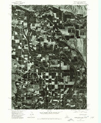
1974 Map of Weiser South
USGS Topo · Published 1975About this map
Snake River dominates this mid-1970s orthophotomap, carving a wide, serpentine path through the irrigated agricultural borderlands between Oregon and Idaho. The intricate patchwork of fields and orchards reveals a highly developed farming landscape, where the geometry of water management dictates the terrain's use. To the north, the town of Weiser is visible at the confluence of several land and water routes, its residential grid and industrial footprints standing in sharp contrast to the surrounding rural sections. This 1974 aerial perspective provides a unique look at the region's agricultural infrastructure and the relationship between the river and the growth of the nearby settlement.
Find a feature on this map
2 named features on this map. Tap any name to fly to it.
Don’t see what you’re looking for? This feature index may not catch every label — zoom into the map to look around manually.
Map Details
Editions of this 1974 Weiser South Map
This is the sole edition of this map. No revisions or reprints were ever made.
Other maps of this area

1897 · Weiser
USGS Topo · 1:125,000

1951 · Moores Hollow
USGS Topo · 1:24,000

1951 · Malheur Butte
USGS Topo · 1:24,000

1951 · Moores Hollow
USGS Topo · 1:62,500

1951 · Payette
USGS Topo · 1:24,000

1951 · Weiser South
USGS Topo · 1:24,000

1952 · Weiser Cove
USGS Topo · 1:24,000

1952 · Birding Island
USGS Topo · 1:24,000

1952 · Olds Ferry
USGS Topo · 1:62,500

1952 · Olds Ferry SE
USGS Topo · 1:24,000