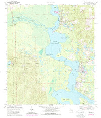
1970 Map of Welaka
USGS Topo · Published 1980About this map
The St Johns River serves as the central artery for this riverfront landscape, where the main channel broadens into Little Lake George and encircles the large landmass of Drayton Island. To the east, the riverside settlements of Welaka, Fruitland, and Georgetown are established along the elevated banks and coves, including Fruitland Cove and Smith Cove. The western shore is dominated by the dense wetlands and pine flatwoods of the Ocala National Forest, through which the meandering Oklawaha River flows toward its confluence. This 1970 edition documents the area before significant modern development, highlighting local landmarks like the National Fish Hatchery and Welaka Springs, as well as several family-named points and coves that define the local geography. The map captures the specialized river-and-lake economy of Putnam County, featuring small landings such as Norwalk Landing and the remote community of Norwalk tucked within the forest bounds.
Find a feature on this map
40 named features on this map. Tap any name to fly to it.
Don’t see what you’re looking for? This feature index may not catch every label — zoom into the map to look around manually.
Map Details
Editions of this 1970 Welaka Map
4 editions found

Other maps of this area

1912 · Palatka
USGS Topo · 1:48,000

1915 · Palatka
USGS Topo · 1:62,500

1915 · Interlachen
USGS Topo · 1:48,000

1916 · Interlachen
USGS Topo · 1:62,500

1944 · Interlachen
USGS Topo · 1:62,500

1949 · Rodman
USGS Topo · 1:24,000

1949 · Interlachen
USGS Topo · 1:62,500

1954 · Daytona Beach
USGS Topo · 1:250,000

1958 · Daytona Beach
USGS Topo · 1:250,000

1964 · Daytona Beach
USGS Topo · 1:250,000