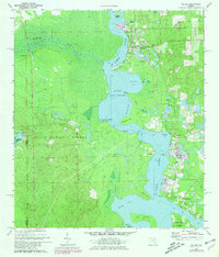
1970 Map of Welaka
USGS Topo · Published 1981About this map
The St Johns River serves as the dominant artery of this Putnam County landscape, where the main channel broadens into Little Lake George and encircles the large, interior landmass of Drayton Island. On the eastern banks, the riverfront settlements of Welaka and Georgetown are detailed alongside established infrastructure like the National Fish Hatchery and local Welaka Springs. The map illustrates a transitional river economy, balancing residential growth near Fruitland with the preserved wetlands of the Ocala National Forest to the west.
Find a feature on this map
43 named features on this map. Tap any name to fly to it.
Don’t see what you’re looking for? This feature index may not catch every label — zoom into the map to look around manually.
Map Details
Editions of this 1970 Welaka Map
4 editions found

Other maps of this area

1912 · Palatka
USGS Topo · 1:48,000

1915 · Palatka
USGS Topo · 1:62,500

1915 · Interlachen
USGS Topo · 1:48,000

1916 · Interlachen
USGS Topo · 1:62,500

1944 · Interlachen
USGS Topo · 1:62,500

1949 · Rodman
USGS Topo · 1:24,000

1949 · Interlachen
USGS Topo · 1:62,500

1954 · Daytona Beach
USGS Topo · 1:250,000

1958 · Daytona Beach
USGS Topo · 1:250,000

1964 · Daytona Beach
USGS Topo · 1:250,000