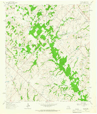
1963 Map of Welcome
USGS Topo · Published 1965About this map
Bleiblerville and the surrounding farm country along the Washington and Austin County line are captured here in the early 1960s. This rural landscape is defined by its deep German-Texan roots, evident in the network of country churches and social landmarks like Germania Hall near the southern boundary. The terrain is intricately carved by numerous drainages including East Mill Creek, Rocky Creek, and Sandy Creek, which supported the early agricultural settlements of Welcome, Wehdem, and Muellersville. Genealogists will find significant value in the detailed plotting of family-linked landmarks such as Mell Cem and the Randle Hill Ch, while the Gulf Colorado and Santa Fe railroad corridor in the northeast shows the vital transport link through Phillipsburg during this era.
Find a feature on this map
42 named features on this map. Tap any name to fly to it.
Don’t see what you’re looking for? This feature index may not catch every label — zoom into the map to look around manually.
Map Details
Editions of this 1963 Welcome Map
3 editions found
Other maps of this area

1919 · Fayettsville
USGS Topo · 1:62,500

1930 · Brenham
USGS Topo · 1:62,500

1953 · Seguin
USGS Topo · 1:250,000

1954 · Austin
USGS Topo · 1:250,000

1956 · Bellville
USGS Topo · 1:62,500

1956 · Brenham
USGS Topo · 1:62,500

1958 · Seguin
USGS Topo · 1:250,000

1958 · Industry
USGS Topo · 1:24,000

1958 · Greenvine
USGS Topo · 1:24,000

1958 · Burton
USGS Topo · 1:24,000