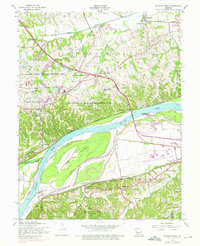
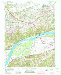
1954 Map of Weldon Spring
USGS Topo · Published 1975About this map
The Missouri River bisects this landscape, creating a distinct boundary between the agricultural lowlands of Howell Island and the developing uplands of St. Charles County. In the mid-20th century, the area transitioned from a rural rail-and-river economy to one influenced by significant industrial and transportation hubs. The massive Weldon Spring Ordnance Works (Abandoned) occupies a substantial portion of the northern terrain, now partially integrated into the August A Busch Memorial Wildlife Area and the University of Missouri Experimental Farm. Along the southern bank, the arrival of the Spirit of St Louis Airport and the expansion of Olive Street Road signal the post-war growth of Chesterfield. Historical family plots and local landmarks like the Cottleville Cem, Wolf Cem, and the Boones Lick Road preserve the earlier pioneer footprint of settlements like Cottleville and Hamburg.
Find a feature on this map
47 named features on this map. Tap any name to fly to it.
Don’t see what you’re looking for? This feature index may not catch every label — zoom into the map to look around manually.
Map Details
Editions of this 1954 Weldon Spring Map
5 editions found
Other maps of this area

1903 · O'Fallon
USGS Topo · 1:125,000

1931 · Manchester SE
USGS Topo · 1:24,000

1931 · Brussels
USGS Topo · 1:62,500

1932 · Manchester NE
USGS Topo · 1:24,000

1937 · Weldon Spring
USGS Topo · 1:24,000

1939 · Brussels
USGS Topo · 1:62,500

1940 · Eureka
USGS Topo · 1:24,000

1940 · Weldon Spring
USGS Topo · 1:24,000

1941 · Troy
USGS Topo · 1:62,500

1943 · Brussels
USGS Topo · 1:62,500