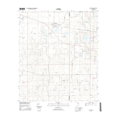
2015 Map of Wellborn
USGS Topo · Published 2015About this map
Wellborn serves as the central hub for this portion of Northern Florida, where the landscape is defined by an intricate network of sinkhole lakes and cypress ponds. The settlement is flanked by Wellborn Lake and the unusually named Grissom Hole, reflecting the karst topography common to Suwannee and Columbia counties. This 2015 data shows a rural community where historical roots are anchored by the Wellborn Cem and McClellan Cem, while the presence of the Wellborn Airport to the northeast suggests modern utility. To the south, the terrain descends toward the Little River, a significant drainage feature for the area. The map illustrates a transition from the structured residential roads of the town center to the sprawling agricultural tracts and natural basins like Bell Prairie and Ogden Lake, demonstrating how local development has historically navigated the region's complex water table.
Find a feature on this map
148 named features on this map. Tap any name to fly to it.
Don’t see what you’re looking for? This feature index may not catch every label — zoom into the map to look around manually.
Map Details
Editions of this 2015 Wellborn Map
This is the sole edition of this map. No revisions or reprints were ever made.
Other maps of this area

1954 · Valdosta
USGS Topo · 1:250,000

1958 · Valdosta
USGS Topo · 1:250,000

1959 · Valdosta
USGS Topo · 1:250,000

1961 · Live Oak East
USGS Topo · 1:24,000

1961 · White Springs East
USGS Topo · 1:24,000

1961 · White Springs West
USGS Topo · 1:24,000

1963 · Columbia
USGS Topo · 1:24,000

1963 · Lake City West
USGS Topo · 1:24,000
1969 · Wellborn
USGS Topo · 1:24,000
1969 · O'Brien
USGS Topo · 1:24,000