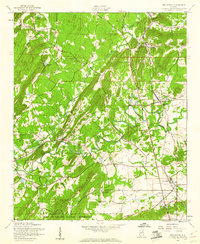
1956 Map of Wellington
USGS Topo · Published 1960About this map
Tallahatchee Creek and Ohatchee Creek wind through this mid-century landscape, framing the industrial and agricultural corridors of Calhoun County. The intersection of the Seaboard Air Line and the Louisville and Nashville railroads at Wellington highlights the area's role as a transportation junction. To the south, the boundary of the Fort Mc Clellan Military Reservation underscores the region's strategic importance during the 1950s.
Find a feature on this map
38 named features on this map. Tap any name to fly to it.
Don’t see what you’re looking for? This feature index may not catch every label — zoom into the map to look around manually.
Map Details
Editions of this 1956 Wellington Map
4 editions found
Other maps of this area

1889 · Springville
USGS Topo · 1:125,000

1892 · Springville
USGS Topo · 1:125,000

1900 · Anniston
USGS Topo · 1:125,000

1947 · Anniston
USGS Topo · 1:24,000

1947 · Dunaway Mountain
USGS Topo · 1:24,000

1947 · Ragland
USGS Topo · 1:62,500

1947 · Colvin Gap
USGS Topo · 1:24,000

1947 · Jacksonville
USGS Topo · 1:24,000

1947 · Glencoe
USGS Topo · 1:24,000

1947 · Wellington
USGS Topo · 1:24,000