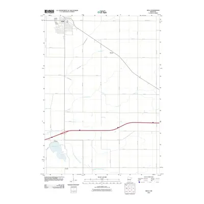
2010 Map of Wells
USGS Topo · Published 2010About this map
Wells anchors the northern portion of this landscape, serving as a primary hub of Faribault County with its grid of streets and the Wells Post Office. The town is flanked by the Rose Hill Cemetery and Saint Casimer Cemetery, reflecting the community's local history and lineage. The surrounding prairie is defined by a systematic network of section-line roads and a complex drainage system, including the engineered County Ditch Number One and various natural waterways like Thisius Branch and Foster Creek.
Find a feature on this map
40 named features on this map. Tap any name to fly to it.
Don’t see what you’re looking for? This feature index may not catch every label — zoom into the map to look around manually.
Map Details
Editions of this 2010 Wells Map
This is the sole edition of this map. No revisions or reprints were ever made.
Other maps of this area

1954 · Mason City
USGS Topo · 1:250,000

1955 · Bricelyn
USGS Topo · 1:62,500

1955 · Wells
USGS Topo · 1:62,500

1957 · Mason City
USGS Topo · 1:250,000

1958 · Mason City
USGS Topo · 1:250,000

1967 · Minnesota Lake
USGS Topo · 1:24,000

1967 · Freeborn
USGS Topo · 1:24,000
1967 · Matawan
USGS Topo · 1:24,000
1982 · Bricelyn
USGS Topo · 1:24,000
1982 · Kiester
USGS Topo · 1:24,000