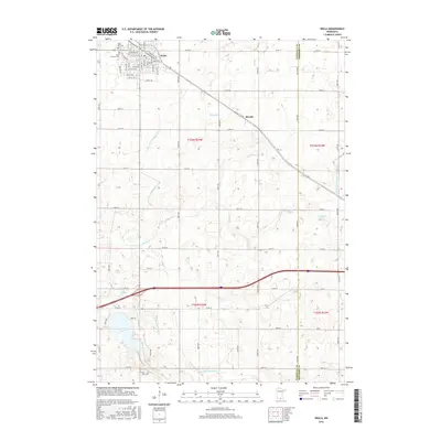
2016 Map of Wells
USGS Topo · Published 2016About this map
Wells anchors the northern edge of this Faribault County landscape, showing a dense street grid that includes local landmarks like Rose Hill Cem and Saint Casimer Cem. The surrounding agricultural countryside is defined by an intricate network of water management and natural drainage, where County Ditch Number One and Judicial Ditch Number Fourteen cut through the terrain to support the region's farming economy. To the south, the Rice Lake basin and the E Br Blue Earth River create a distinct wetland environment, punctuated by the Rice Lake Cem on its southern shore. The small settlement of Baroda sits along a diagonal corridor, illustrating the rural hamlet patterns that persisted alongside the larger township centers. This survey captures the highly organized section-line road system, such as Co Rd 32 and 170th St, which connects isolated farmsteads across the prairie.
Find a feature on this map
37 named features on this map. Tap any name to fly to it.
Don’t see what you’re looking for? This feature index may not catch every label — zoom into the map to look around manually.
Map Details
Editions of this 2016 Wells Map
This is the sole edition of this map. No revisions or reprints were ever made.
Other maps of this area

1954 · Mason City
USGS Topo · 1:250,000

1955 · Bricelyn
USGS Topo · 1:62,500

1955 · Wells
USGS Topo · 1:62,500

1957 · Mason City
USGS Topo · 1:250,000

1958 · Mason City
USGS Topo · 1:250,000

1967 · Minnesota Lake
USGS Topo · 1:24,000

1967 · Freeborn
USGS Topo · 1:24,000
1967 · Matawan
USGS Topo · 1:24,000
1982 · Bricelyn
USGS Topo · 1:24,000
1982 · Kiester
USGS Topo · 1:24,000