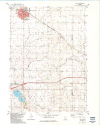
1982 Map of Wells
USGS Topo · Published 1983About this map
The city of Wells serves as the primary hub of this Faribault County landscape, defined by its organized grid and intersection of rail and road. The Chicago Milwaukee St Paul and Pacific railroad cuts a sharp diagonal through the prairie, passing by smaller points like Shorty, Thistius, and Baroda. This era shows a well-established agricultural and civic infrastructure, from the City Hall and hospital in town to the St Casimir Ch and several local burial grounds including Rose Hill Cem and St Casimir Cem.
Find a feature on this map
30 named features on this map. Tap any name to fly to it.
Don’t see what you’re looking for? This feature index may not catch every label — zoom into the map to look around manually.
Map Details
Editions of this 1982 Wells Map
This is the sole edition of this map. No revisions or reprints were ever made.
Other maps of this area

1954 · Mason City
USGS Topo · 1:250,000

1955 · Bricelyn
USGS Topo · 1:62,500

1955 · Wells
USGS Topo · 1:62,500

1957 · Mason City
USGS Topo · 1:250,000

1958 · Mason City
USGS Topo · 1:250,000

1967 · Minnesota Lake
USGS Topo · 1:24,000

1967 · Freeborn
USGS Topo · 1:24,000
1967 · Matawan
USGS Topo · 1:24,000
1982 · Bricelyn
USGS Topo · 1:24,000
1982 · Kiester
USGS Topo · 1:24,000