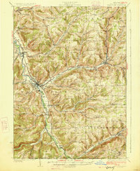
1926 Map of Wellsville
USGS Topo · Published 1926About this map
Wellsville serves as the industrial and population hub of this 1920s Allegany County survey, situated where the Genesee River meets the heavy rail traffic of the Erie RR. The map records a landscape transitioning from early rural settlements like Irish Settlement and Paynesville toward a more connected regional economy. Evidence of earlier infrastructure remains visible at Stone Dam and the Weidrich Bridge, while the Liberty Highway cuts through the river valleys. The topography is defined by significant elevations such as Tip Top and Round Top, with numerous numbered schools like School No 9 and School No 10 serving the dispersed farming communities in townships like Willing and Independence. Along the southern edge, the New York Pennsylvania Boundary Line marks the limit of the state’s jurisdiction near the headwaters of Cryder Creek.
Find a feature on this map
65 named features on this map. Tap any name to fly to it.
Don’t see what you’re looking for? This feature index may not catch every label — zoom into the map to look around manually.
Map Details
Editions of this 1926 Wellsville Map
5 editions found
Other maps of this area

1899 · Gaines
USGS Topo · 1:62,500

1900 · Gaines
USGS Topo · 1:62,500

1906 · Angelica
USGS Topo · 1:62,500

1915 · Hornell
USGS Topo · 1:62,500

1916 · Canaseraga
USGS Topo · 1:62,500

1918 · Hornell
USGS Topo · 1:62,500

1925 · Belmont
USGS Topo · 1:62,500

1926 · Wellsville
USGS Topo · 1:62,500

1926 · Greenwood
USGS Topo · 1:62,500

1932 · Genesee
USGS Topo · 1:62,500