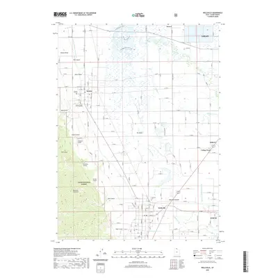
2020 Map of Wellsville
USGS Topo · Published 2020About this map
Wellsville and Mendon anchor the western edge of Cache Valley in this 2020 survey, where the steep eastern slopes of the Wasatch Range meet a complex network of waterways. The transition from the high Wellsville Mountains to the valley floor is marked by numerous drainage features such as Deep Canyon, Coldwater Canyon, and Pine Canyon. Below these peaks, the landscape is defined by irrigation and recreation, featuring the Wellsville-Mendon Lower Canal and the Blacksmith Fork Hyrum Canal. The Little Bear River meanders through the central valley, creating unique landforms like The Island and supporting recreational paths including the Little Bear River Canoe Trail and N Marsh Canoe Trail. Genealogists will find the Wellsville Cem and Mendon City Cem clearly marked, serving the historic communities that have farmed this region for generations. To the northeast, the outskirts of Logan and the community of College Ward illustrate the modern agricultural and residential footprint of the county.
Find a feature on this map
79 named features on this map. Tap any name to fly to it.
Don’t see what you’re looking for? This feature index may not catch every label — zoom into the map to look around manually.
Map Details
Editions of this 2020 Wellsville Map
This is the sole edition of this map. No revisions or reprints were ever made.
Other maps of this area

1914 · Logan
USGS Topo · 1:125,000

1916 · Logan
USGS Topo · 1:125,000

1954 · Ogden
USGS Topo · 1:250,000

1954 · Brigham City
USGS Topo · 1:250,000

1955 · Paradise
USGS Topo · 1:24,000

1955 · Mount Pisgah
USGS Topo · 1:24,000

1955 · Brigham City
USGS Topo · 1:24,000

1958 · Ogden
USGS Topo · 1:250,000

1958 · Brigham City
USGS Topo · 1:250,000

1960 · Ogden
USGS Topo · 1:250,000