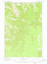
1967 Map of Wenaha Forks
USGS Topo · Published 1972About this map
Umatilla National Forest defines this remote corner of Oregon and Washington as it appeared in the late 1960s. The terrain is characterized by steep drainage systems like Trapper Canyon and prominent elevations such as Round Butte and Beaver Ridge. This map captures a wilderness area before modern road development, where access was primarily managed through a network of Pack Trails and a single Jeep Trail winding through the interior. At the center of the sheet, Wenaha Forks marks the confluence where the North Fork Sawtooth meets the Wenaha River. The geography is dotted with remote water sources essential for forest navigation, including Peerless Spring and the open ground of Elk Flat near the eastern boundary.
Find a feature on this map
25 named features on this map. Tap any name to fly to it.
Don’t see what you’re looking for? This feature index may not catch every label — zoom into the map to look around manually.
Map Details
Editions of this 1967 Wenaha Forks Map
3 editions found
Other maps of this area

1937 · Pomeroy
USGS Topo · 1:96,000

1942 · Pomeroy
USGS Topo · 1:125,000

1955 · Pullman
USGS Topo · 1:250,000

1955 · Grangeville
USGS Topo · 1:250,000

1958 · Pullman
USGS Topo · 1:250,000

1959 · Grangeville
USGS Topo · 1:250,000

1967 · Fry Meadow
USGS Topo · 1:24,000

1967 · Elbow Creek
USGS Topo · 1:24,000
1967 · Bone Spring
USGS Topo · 1:24,000

1967 · Oregon Butte
USGS Topo · 1:24,000