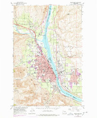
1966 Map of Wenatchee
USGS Topo · Published 1978About this map
The Columbia River serves as the central artery for this mid-1960s survey, dividing the growing city of Wenatchee from East Wenatchee and the high plateaus of Douglas Co. The landscape reveals a transition from the industrial activity at Appleyard and the Burlington Northern rail lines to the fruit-growing terraces of Birch Flat and Baker Flats. Significant local infrastructure is present, including Fancher Field and a network of irrigation features like the aqueduct and various ditches that supported the region's agriculture.
Find a feature on this map
88 named features on this map. Tap any name to fly to it.
Don’t see what you’re looking for? This feature index may not catch every label — zoom into the map to look around manually.
Map Details
Editions of this 1966 Wenatchee Map
5 editions found
Other maps of this area

1901 · Chelan
USGS Topo · 1:125,000

1912 · Malaga
USGS Topo · 1:48,000

1913 · Wenatchee
USGS Topo · 1:62,500

1914 · Malaga
USGS Topo · 1:62,500

1915 · Wenatchee
USGS Topo · 1:62,500

1920 · Colockum Pass
USGS Topo · 1:125,000

1922 · Colockum Pass
USGS Topo · 1:125,000

1957 · Wenatchee
USGS Topo · 1:250,000

1966 · Rock Island
USGS Topo · 1:24,000

1966 · Wenatchee
USGS Topo · 1:24,000