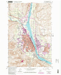
1966 Map of Wenatchee
USGS Topo · Published 1988About this map
Columbia River serves as the dividing line between Chelan and Douglas counties in this mid-century look at the hub of Washington's apple country. The city of Wenatchee is shown in detail, revealing the urban expansion of the 1960s and 1980s alongside long-standing landmarks like Wenatchee Valley Jr College and the High School. Across the water, East Wenatchee and Fancher Field airport anchor the Douglas County side, while the industrial and rail activities at Appleyard and along the Burlington Northern tracks highlight the area's role as a transportation nexus.
Find a feature on this map
82 named features on this map. Tap any name to fly to it.
Don’t see what you’re looking for? This feature index may not catch every label — zoom into the map to look around manually.
Map Details
Editions of this 1966 Wenatchee Map
5 editions found
Other maps of this area

1901 · Chelan
USGS Topo · 1:125,000

1912 · Malaga
USGS Topo · 1:48,000

1913 · Wenatchee
USGS Topo · 1:62,500

1914 · Malaga
USGS Topo · 1:62,500

1915 · Wenatchee
USGS Topo · 1:62,500

1920 · Colockum Pass
USGS Topo · 1:125,000

1922 · Colockum Pass
USGS Topo · 1:125,000

1957 · Wenatchee
USGS Topo · 1:250,000

1966 · Rock Island
USGS Topo · 1:24,000

1966 · Wenatchee
USGS Topo · 1:24,000