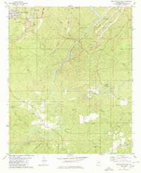
1980 Map of West Blocton East
USGS Topo · Published 1980About this map
The Cahaba River and Little Cahaba River wind through this part of Bibb County, shaping a landscape defined by industrial extraction and small riverside communities. Around West Blocton, the map reveals a heavy concentration of Strip Mine activity and Gravel Pits, including a significant Tailings Pond near Smith Hill. These mining operations are interspersed with numerous family-named water features like Coffee Creek and Ugly Creek, illustrating the complex relationship between the natural watershed and the coal and gravel industries of the late 20th century.
Find a feature on this map
42 named features on this map. Tap any name to fly to it.
Don’t see what you’re looking for? This feature index may not catch every label — zoom into the map to look around manually.
Map Details
Editions of this 1980 West Blocton East Map
2 editions found
Other maps of this area

1890 · Bessemer
USGS Topo · 1:125,000

1891 · Clanton
USGS Topo · 1:125,000

1892 · Bessemer
USGS Topo · 1:125,000

1899 · Brookwood
USGS Topo · 1:125,000

1910 · Montevallo
USGS Topo · 1:62,500

1934 · Blocton
USGS Topo · 1:48,000

1940 · Blocton
USGS Topo · 1:62,500

1953 · Montgomery
USGS Topo · 1:250,000

1953 · Birmingham
USGS Topo · 1:250,000

1956 · Birmingham
USGS Topo · 1:250,000