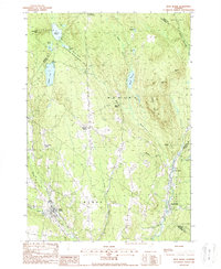
1988 Map of West Burke
USGS Topo · Published 1988About this map
The East Branch Passumpsic River and its numerous tributaries define this corner of the Northeast Kingdom in the late 1980s. The landscape is a network of ridges and water bodies, including the central Center Pond and Newark Pond to the west. Small settlements and local crossroads like Newark Street, Newark Hollow, and Hartwellville are connected by winding valley roads that trace the movement of water through the hills.
Find a feature on this map
39 named features on this map. Tap any name to fly to it.
Don’t see what you’re looking for? This feature index may not catch every label — zoom into the map to look around manually.
Map Details
Editions of this 1988 West Burke Map
2 editions found
Other maps of this area

1919 · Lake Memphremagog
USGS Topo · 1:62,500

1920 · Derby
USGS Topo · 1:62,500

1923 · Lake Memphremagog
USGS Topo · 1:48,000

1924 · Island Pond
USGS Topo · 1:48,000

1925 · Memphremagog
USGS Topo · 1:62,500

1926 · Island Pond
USGS Topo · 1:62,500

1935 · Lyndonville
USGS Topo · 1:48,000

1939 · Lyndonville
USGS Topo · 1:62,500

1950 · Lake Champlain
USGS Topo · 1:250,000

1950 · Lewiston
USGS Topo · 1:250,000