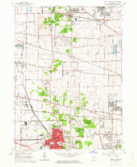
1962 Map of West Chicago
USGS Topo · Published 1963About this map
West Chicago serves as the industrial and transit anchor of this 1962 landscape, where five major rail lines converge. The Chicago and North Western and Elgin Joliet and Eastern railroads create a dense grid of tracks through the city center, while smaller stops like Munger Station and Prince Crossing dot the outlying agricultural areas. The West Branch of the Du Page River winds through the central terrain, bordered by the Wayne Grove Forest Preserve and Pratt Wayne Woods Forest Preserve. This era captures a mix of established rural institutions and suburban expansion, evidenced by the Wheaton College Academy and Christ the King Seminary standing alongside emerging residential developments in Carol Stream and Streamwood. Numerous burial grounds, including the Old Ontarioville Cem and the unique Illinois Pet Cemetery, offer specific points of interest for local historians.
Find a feature on this map
82 named features on this map. Tap any name to fly to it.
Don’t see what you’re looking for? This feature index may not catch every label — zoom into the map to look around manually.
Map Details
Editions of this 1962 West Chicago Map
4 editions found
Other maps of this area

1908 · Wheaton
USGS Topo · 1:62,500

1923 · Barrington
USGS Topo · 1:62,500

1925 · Elgin
USGS Topo · 1:62,500

1932 · Geneva
USGS Topo · 1:62,500

1935 · Barrington
USGS Topo · 1:62,500

1940 · Elgin
USGS Topo · 1:62,500

1948 · Wheaton
USGS Topo · 1:62,500

1948 · Geneva
USGS Topo · 1:62,500

1949 · Geneva
USGS Topo · 1:24,000

1950 · Aurora North
USGS Topo · 1:24,000