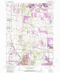
1962 Map of West Chicago
USGS Topo · Published 1988About this map
West Chicago and its surrounding townships show the transition of DuPage County from an agricultural and rail-oriented landscape to a suburban corridor. The rail network remains the backbone of the region, featuring the Chicago and North Western and the Elgin Joliet and Eastern lines intersecting near the heart of the city. Purple-shaded revisions indicate the rapid post-war expansion of Hanover Park and Carol Stream, while older rural nodes like Ontarioville and Munger Station retain their distinct identities. Local history is deeply etched into the land through sites like the Christ the King Seminary and several family or community burial grounds, including the Old Ontarioville Cem and the Wayne Center Cem. Conservation efforts are also visible in the preserved green spaces of Pratts Wayne Woods Forest Preserve and Wayne Grove Forest Preserve along the West Branch Du Page River.
Find a feature on this map
58 named features on this map. Tap any name to fly to it.
Don’t see what you’re looking for? This feature index may not catch every label — zoom into the map to look around manually.
Map Details
Editions of this 1962 West Chicago Map
4 editions found
Other maps of this area

1908 · Wheaton
USGS Topo · 1:62,500

1923 · Barrington
USGS Topo · 1:62,500

1925 · Elgin
USGS Topo · 1:62,500

1932 · Geneva
USGS Topo · 1:62,500

1935 · Barrington
USGS Topo · 1:62,500

1940 · Elgin
USGS Topo · 1:62,500

1948 · Wheaton
USGS Topo · 1:62,500

1948 · Geneva
USGS Topo · 1:62,500

1949 · Geneva
USGS Topo · 1:24,000

1950 · Aurora North
USGS Topo · 1:24,000