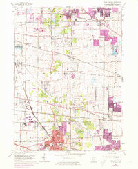
1962 Map of West Chicago
USGS Topo · Published 1973About this map
West Chicago and its neighboring DuPage County townships sit at a major rail crossroads in the early 1960s, defined by the heavy infrastructure of the Chicago and North Western and the Elgin Joliet and Eastern lines. The landscape reveals a transition from traditional rural homesteads to mid-century suburban expansion, particularly around Bartlett, Streamwood, and the developing area of Carol Stream. Significant educational and religious landmarks are scattered across the terrain, including Christ the King Seminary, the Wheaton College Academy, and the McAuley Sch.
Find a feature on this map
72 named features on this map. Tap any name to fly to it.
Don’t see what you’re looking for? This feature index may not catch every label — zoom into the map to look around manually.
Map Details
Editions of this 1962 West Chicago Map
4 editions found
Other maps of this area

1908 · Wheaton
USGS Topo · 1:62,500

1923 · Barrington
USGS Topo · 1:62,500

1925 · Elgin
USGS Topo · 1:62,500

1932 · Geneva
USGS Topo · 1:62,500

1935 · Barrington
USGS Topo · 1:62,500

1940 · Elgin
USGS Topo · 1:62,500

1948 · Wheaton
USGS Topo · 1:62,500

1948 · Geneva
USGS Topo · 1:62,500

1949 · Geneva
USGS Topo · 1:24,000

1950 · Aurora North
USGS Topo · 1:24,000