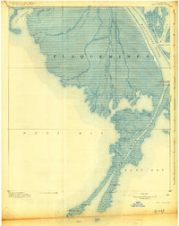
1893 Map of West Delta
USGS Topo · Published 1928About this map
The deltaic finger of the South West Pass extends deep into the Gulf of Mexico, anchoring this maritime survey of the southernmost reaches of Plaquemines Parish. Topography compiled by H.L. Baldwin Jr. captures the precarious landscape of the lower Mississippi River, where the entire area sits less than five feet above sea level. This is a world of navigational infrastructure and shifting silts, dominated by the branching distributaries of Grand Pass, Tiger Pass, and Williams Pass.
Find a feature on this map
25 named features on this map. Tap any name to fly to it.
Don’t see what you’re looking for? This feature index may not catch every label — zoom into the map to look around manually.
Map Details
Editions of this 1893 West Delta Map
3 editions found
Other maps of this area

1892 · Quarantine
USGS Topo · 1:62,500

1893 · East Delta
USGS Topo · 1:62,500

1893 · Forts
USGS Topo · 1:62,500

1893 · West Delta
USGS Topo · 1:62,500

1935 · South Pass
USGS Topo · 1:31,680

1941 · Empire
USGS Topo · 1:62,500

1944 · Empire
USGS Topo · 1:62,500

1946 · Pass Du Bois
USGS Topo · 1:31,680

1946 · Mudpan Bayou
USGS Topo · 1:31,680

1946 · Pass Tante Phine
USGS Topo · 1:31,680