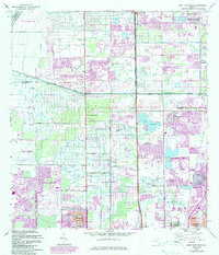
1962 Map of West Dixie Bend
USGS Topo · Published 1983About this map
The Hills Boro Canal serves as a prominent boundary line on this Florida landscape, separating the developing suburban tracts of Coral Springs and Parkland from the burgeoning coastal municipalities to the east. During the early 1960s, this region was undergoing a significant transformation from agricultural and open land into a network of residential communities and golf courses. Notable pockets of established community life appear at New Jerusalem Ch and smaller settlements like West Dixie Bend and Lakeview.
Find a feature on this map
40 named features on this map. Tap any name to fly to it.
Don’t see what you’re looking for? This feature index may not catch every label — zoom into the map to look around manually.
Map Details
Editions of this 1962 West Dixie Bend Map
3 editions found
Other maps of this area

1945 · Fort Lauderdale North
USGS Topo · 1:24,000

1946 · West Dixie Bend
USGS Topo · 1:24,000

1946 · Boca Raton
USGS Topo · 1:24,000

1947 · Delmar Farms
USGS Topo · 1:24,000

1949 · Fort Lauderdale North
USGS Topo · 1:24,000

1949 · West Dixie Bend
USGS Topo · 1:24,000

1949 · Pompano Beach
USGS Topo · 1:24,000

1949 · Delmar Farms
USGS Topo · 1:24,000

1950 · Boca Raton
USGS Topo · 1:24,000

1950 · Delray Beach
USGS Topo · 1:24,000