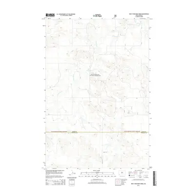
2014 Map of West Fork Deep Creek
USGS Topo · Published 2014About this map
Little Missouri National Grassland dominates this section of the North Dakota badlands, where the drainage of the W Fork Deep Cr carves a complex network of coulees and ridges. The terrain transitions south across the border between Slope Co and Bowman Co, revealing a landscape defined by its topography rather than dense settlement. While much of the land remains part of the public grassland, small local thoroughfares like 80th St SW and 153rd Ave SW provide access to the remote interior. The confluence of the W Fork Deep Cr and E Fork Deep Cr forms the headwaters of Deep Cr, illustrating the vital hydrological patterns that dictate movement and grazing in this arid environment.
Find a feature on this map
16 named features on this map. Tap any name to fly to it.
Don’t see what you’re looking for? This feature index may not catch every label — zoom into the map to look around manually.
Map Details
Editions of this 2014 West Fork Deep Creek Map
This is the sole edition of this map. No revisions or reprints were ever made.
Other maps of this area

1953 · Dickinson
USGS Topo · 1:250,000

1957 · Dickinson
USGS Topo · 1:250,000

1968 · Bowman
USGS Topo · 1:24,000

1973 · Black Butte
USGS Topo · 1:24,000

1973 · Stewart Lake
USGS Topo · 1:24,000

1973 · Griffin
USGS Topo · 1:24,000

1973 · Rhame
USGS Topo · 1:24,000

1979 · Ives
USGS Topo · 1:24,000

1981 · Bowman
USGS Topo · 1:100,000
1997 · Stewart Lake
USGS Topo · 1:24,000