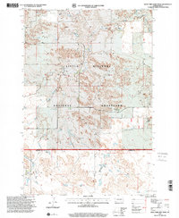
1997 Map of West Fork Deep Creek
USGS Topo · Published 2001About this map
Little Missouri National Grassland dominates this portion of the North Dakota badlands, where the drainage of West Fork Deep Creek and Deep Creek carves a complex network of coulees and ridges. The landscape is defined by its wide-open ranching character in the late twentieth century, notably represented by the Bloomgren Ranch located east of the main creek fork. Historically significant township divisions like Harper, Slope Center, and Marion provide a structured grid over the dissected terrain, marking the intersection of Slope and Bowman counties. Sparse industrial activity is evident through occasional Gravel Pits, while a series of unimproved roads and trails suggests a rural economy focused on land management and grazing within the national forest system.
Find a feature on this map
9 named features on this map. Tap any name to fly to it.
Don’t see what you’re looking for? This feature index may not catch every label — zoom into the map to look around manually.
Map Details
Editions of this 1997 West Fork Deep Creek Map
This is the sole edition of this map. No revisions or reprints were ever made.
Other maps of this area

1953 · Dickinson
USGS Topo · 1:250,000

1957 · Dickinson
USGS Topo · 1:250,000

1968 · Bowman
USGS Topo · 1:24,000

1973 · Black Butte
USGS Topo · 1:24,000

1973 · Stewart Lake
USGS Topo · 1:24,000

1973 · Griffin
USGS Topo · 1:24,000

1973 · Rhame
USGS Topo · 1:24,000

1979 · Ives
USGS Topo · 1:24,000

1981 · Bowman
USGS Topo · 1:100,000
1997 · Stewart Lake
USGS Topo · 1:24,000