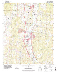
1994 Map of West Fork
USGS Topo · Published 1998About this map
West Fork and Greenland sit along the winding valley of the West Fork White River during a period of significant infrastructure development in Washington County. Evidence of mid-1990s expansion is clear through the prominent Under Construction markings along the primary highway corridor, which bypasses older centers like Woolsey and Pitkin Corner. The terrain is defined by a series of named heights including Miller Mountain, Fraker Mountain, and Bloyd Mountain, creating a landscape where small communities and family landmarks are tucked into the drainages of Hickory Creek and Dye Creek. Genealogists will find a high concentration of burial sites, from the Union Star Cem near the river to the upland Boone Cem and Mineral Springs Cem. Rural religious life is represented by local landmarks such as Friendship Ch and Mt Gap Ch, while industrial activity is noted at the Quarries west of the river.
Find a feature on this map
39 named features on this map. Tap any name to fly to it.
Don’t see what you’re looking for? This feature index may not catch every label — zoom into the map to look around manually.
Map Details
Editions of this 1994 West Fork Map
2 editions found
Other maps of this area

1898 · Winslow
USGS Topo · 1:125,000

1899 · Fayetteville
USGS Topo · 1:125,000

1901 · Winslow
USGS Topo · 1:125,000

1901 · Fayetteville
USGS Topo · 1:125,000

1904 · Fayetteville
USGS Topo · 1:125,000

1946 · Fort Smith
USGS Topo · 1:250,000

1954 · Tulsa
USGS Topo · 1:250,000

1958 · Fayetteville
USGS Topo · 1:24,000

1958 · Elkins
USGS Topo · 1:24,000

1958 · Tulsa
USGS Topo · 1:250,000