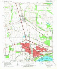
1966 Map of West Memphis
USGS Topo · Published 1967About this map
West Memphis sits at a critical intersection of river and rail commerce along the Mississippi River in the mid-1960s. The landscape is defined by the heavy infrastructure of the Missouri Pacific, St Louis - San Francisco, and Rock Island and Pacific railroads, which converge near the town of Marion. The area shows a transition from the agricultural bottomlands of Lloyd Bottom to the expanding suburban footprint of West Memphis, characterized by new residential developments like Avondale Park and major civic landmarks including the Crittenden Memorial Hospital and the Southland Park Racetrack. To the north, the terrain is shaped by an extensive network of drainage projects such as Ditch No 16 and Tenmile Bayou Diversion Ditch, reflecting the ongoing efforts to manage the low-lying Delta lands for settlement and industry.
Find a feature on this map
77 named features on this map. Tap any name to fly to it.
Don’t see what you’re looking for? This feature index may not catch every label — zoom into the map to look around manually.
Map Details
Editions of this 1966 West Memphis Map
3 editions found
Other maps of this area

1916 · Memphis
USGS Topo · 1:62,500

1925 · Memphis
USGS Topo · 1:48,000

1927 · Memphis
USGS Topo · 1:62,500

1931 · Jericho
USGS Topo · 1:62,500

1939 · Jericho
USGS Topo · 1:62,500

1939 · Edmondson
USGS Topo · 1:62,500

1939 · Memphis
USGS Topo · 1:62,500

1940 · Deckerville
USGS Topo · 1:62,500

1952 · Jericho
USGS Topo · 1:62,500

1953 · Memphis
USGS Topo · 1:250,000