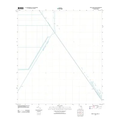
2012 Map of West of Big Lake
USGS Topo · Published 2012About this map
Water management and agricultural infrastructure define this corner of Palm Beach County, where the Hillsboro Canal cuts a straight path across the Florida landscape. This early 21st-century survey documents the engineered environment of the Everglades' edge, characterized by an extensive system of protective embankments including Levee 15, Levee 7, and Levee 6. These structures, alongside the L-7 Canal, illustrate the scale of hydrological modification required to support the region's agricultural interests. Brown's Farm Rd runs parallel to the canal in the southeastern portion of the map, providing a terrestrial link through this area of controlled waterways and drainage basins. The landscape is dominated by the intersection of these man-made features, specifically where the canal system and Levee 39 converge to manage the flow of water across this low-lying territory.
Find a feature on this map
7 named features on this map. Tap any name to fly to it.
Don’t see what you’re looking for? This feature index may not catch every label — zoom into the map to look around manually.
Map Details
Editions of this 2012 West of Big Lake Map
This is the sole edition of this map. No revisions or reprints were ever made.
Other maps of this area

1956 · West Palm Beach
USGS Topo · 1:250,000

1957 · West Palm Beach
USGS Topo · 1:250,000

1958 · West Palm Beach
USGS Topo · 1:250,000

1963 · Fort Lauderdale 2 SE
USGS Topo · 1:24,000
1970 · Loxahatchee SE
USGS Topo · 1:24,000

1970 · Loxahatchee SW
USGS Topo · 1:24,000

1970 · Shawano
USGS Topo · 1:24,000
1973 · Fort Lauderdale 2 NE
USGS Topo · 1:24,000

1973 · Fort Lauderdale 2 SW
USGS Topo · 1:24,000

1974 · Everglades 1 SE
USGS Topo · 1:24,000