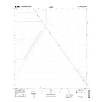
2015 Map of West of Big Lake
USGS Topo · Published 2015About this map
Water management infrastructure and utility access define this corner of Palm Beach County, where the Hillsboro Canal cuts a sharp diagonal path across the landscape. This man-made waterway, critical to the reclamation and drainage efforts that transformed South Florida, is paralleled by Browns Farm Rd, providing a lonely transit corridor through the surrounding wetlands. In the northwestern portion of the sheet, the L-7 Canal provides further evidence of the region's highly engineered hydrology. The stark, geometric layout of these features reflects the mid-century evolution of the Everglades into a managed system of levees and channels designed to control water flow and support agricultural expansion in the interior of the state.
Find a feature on this map
3 named features on this map. Tap any name to fly to it.
Don’t see what you’re looking for? This feature index may not catch every label — zoom into the map to look around manually.
Map Details
Editions of this 2015 West of Big Lake Map
This is the sole edition of this map. No revisions or reprints were ever made.
Other maps of this area

1956 · West Palm Beach
USGS Topo · 1:250,000

1957 · West Palm Beach
USGS Topo · 1:250,000

1958 · West Palm Beach
USGS Topo · 1:250,000

1963 · Fort Lauderdale 2 SE
USGS Topo · 1:24,000
1970 · Loxahatchee SE
USGS Topo · 1:24,000

1970 · Loxahatchee SW
USGS Topo · 1:24,000

1970 · Shawano
USGS Topo · 1:24,000
1973 · Fort Lauderdale 2 NE
USGS Topo · 1:24,000

1973 · Fort Lauderdale 2 SW
USGS Topo · 1:24,000

1974 · Everglades 1 SE
USGS Topo · 1:24,000