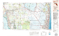
1987 Map of West Palm Beach
USGS Topo · Published 1988About this map
Lake Okeechobee dominates the northern interior of this 1980s survey, anchoring a complex hydrological network of engineered canals and ancient sloughs that define South Florida's landscape. The map illustrates the managed flow of water through the Miami Canal, Hillsboro Canal, and West Palm Beach Canal, cutting through the vast expanse of The Everglades. While the Atlantic coast shows dense urban development from West Palm Beach down to Hollywood, the interior remains a mosaic of preservation and indigenous lands, including the Big Cypress Seminole Indian Reservation and the Miccosukee Indian Reservation. Transport corridors like the Alligator Alley and the Seaboard System Railroad provide the primary east-west links across the swampy terrain. This edition provides a clear record of the region's mid-80s infrastructure before the intensive restoration efforts and further suburban expansion of the late 20th century.
Find a feature on this map
111 named features on this map. Tap any name to fly to it.
Don’t see what you’re looking for? This feature index may not catch every label — zoom into the map to look around manually.
Map Details
Editions of this 1987 West Palm Beach Map
2 editions found
Other maps of this area

1945 · Fort Lauderdale North
USGS Topo · 1:24,000

1945 · Delta
USGS Topo · 1:24,000

1945 · Greenacres City
USGS Topo · 1:24,000

1945 · Lake Worth
USGS Topo · 1:24,000

1946 · Riviera Beach
USGS Topo · 1:24,000

1946 · West Dixie Bend
USGS Topo · 1:24,000

1946 · Boca Raton
USGS Topo · 1:24,000

1946 · Palm Beach Farms
USGS Topo · 1:24,000

1946 · Palm Beach
USGS Topo · 1:24,000

1947 · North Miami
USGS Topo · 1:24,000