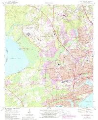
1970 Map of West Pensacola
USGS Topo · Published 1988About this map
U S Navy Air Base Saufley Field dominates the central landscape of this western Florida coastal region, marking a transition between the established communities of Bellview and the waters of Perdido Bay. The map documents a period of significant suburban expansion, with extensive housing developments and mobile home parks pushing into the woodlands between Eightmile Creek and Marcus Bayou. Coastal life is centered around the intricate shorelines of Bayou Grande and Chico Bayou, where residential neighborhoods like Navy Point and Beach Haven interface with military installations and the open waters of Pensacola Bay. To the west, the rural character persists near Klondike and the Elevenmile Creek drainage, providing a contrast to the dense grid of West Pensacola and Brownsville. This survey also meticulously records local spiritual and educational hubs, including Spring Hill Ch and Wedgewood Middle Sch, alongside several community burial grounds like Myrtle Grove Cem.
Find a feature on this map
70 named features on this map. Tap any name to fly to it.
Don’t see what you’re looking for? This feature index may not catch every label — zoom into the map to look around manually.
Map Details
Editions of this 1970 West Pensacola Map
2 editions found

Other maps of this area

1920 · Milton
USGS Topo · 1:62,500

1921 · Pensacola
USGS Topo · 1:62,500

1921 · Fort Barrancas
USGS Topo · 1:62,500

1921 · Muscogee
USGS Topo · 1:62,500

1941 · Fort Barrancas
USGS Topo · 1:62,500

1941 · Muscogee
USGS Topo · 1:62,500

1941 · Pensacola
USGS Topo · 1:62,500

1941 · Milton
USGS Topo · 1:62,500

1942 · Pensacola
USGS Topo · 1:62,500

1943 · Muscogee
USGS Topo · 1:62,500