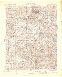
1946 Map of West Plains
USGS Topo · Published 1946About this map
West Plains serves as the regional hub for Howell County in the mid-1940s, anchored by the St Louis - San Francisco railroad. The landscape is a network of small upland communities and rural school districts, including Langston Sch, Bradford Sch, and Homeland Sch, reflecting a highly localized agrarian society. To the south, the terrain follows the South Fork Spring River and its many tributaries like Myatt Creek and Mustion Creek, where family-named sites such as the Mc Elmerry Cem and Brown Chapel mark the long-standing settlements near the Arkansas border. The presence of the County Home and American Legion Field near the city center provides a glimpse into the civic infrastructure and social life of the era before post-war suburban expansion altered the local geography.
Find a feature on this map
65 named features on this map. Tap any name to fly to it.
Don’t see what you’re looking for? This feature index may not catch every label — zoom into the map to look around manually.
Map Details
Editions of this 1946 West Plains Map
2 editions found

Other maps of this area

1890 · Mountain Home
USGS Topo · 1:125,000

1891 · Mountain Home
USGS Topo · 1:125,000

1894 · Mountain Home
USGS Topo · 1:125,000

1938 · West Plains
USGS Topo · 1:24,000

1939 · Topaz
USGS Topo · 1:62,500

1940 · West Plains
USGS Topo · 1:24,000

1941 · Topaz
USGS Topo · 1:62,500

1943 · Thayer
USGS Topo · 1:62,500

1944 · West Plains
USGS Topo · 1:62,500

1944 · Cureall
USGS Topo · 1:62,500