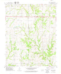
1975 Map of West Point
USGS Topo · Published 1979About this map
The Old Indian Treaty Boundary cuts through this landscape, dividing the northern township from the intensive energy production to the south. Centered on the settlement of West Point, this 1975 survey documents an Oklahoma countryside undergoing industrial shift, where expansive oil fields and numerous Oil Wells populate the terrain near Salt Creek. The transition from agrarian history to mid-century infrastructure is evident in the presence of the Cimarron Toll Road Turnpike bisecting the northern half of the map, complete with its dedicated Service Facility. Local history is anchored by several rural burial grounds, including Mt Vernon Cem and Mt Pleasant Cem, while the secluded Camp Koinonia and the seasonal waters of Camp Creek define the quiet southwestern reaches.
Find a feature on this map
24 named features on this map. Tap any name to fly to it.
Don’t see what you’re looking for? This feature index may not catch every label — zoom into the map to look around manually.
Map Details
Editions of this 1975 West Point Map
This is the sole edition of this map. No revisions or reprints were ever made.
Other maps of this area

1929 · Yale
USGS Topo · 1:62,500

1929 · Ripley
USGS Topo · 1:62,500

1929 · Skedee
USGS Topo · 1:62,500

1930 · Pawnee
USGS Topo · 1:62,500

1931 · Skedee
USGS Topo · 1:62,500

1932 · Yale
USGS Topo · 1:62,500

1932 · Ripley
USGS Topo · 1:62,500

1936 · Pawnee
USGS Topo · 1:62,500

1955 · Enid
USGS Topo · 1:250,000

1958 · Enid
USGS Topo · 1:250,000