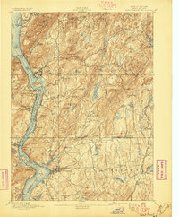
1894 Map of West Point
USGS Topo · Published 1897About this map
The Hudson River Highlands dominate this 1890s survey, illustrating a landscape defined by dramatic topography and strategic military history. At the heart of the reach lies West Point, where the river narrows sharply between Constitution Island and Gees Pt. The map documents the fortified heights of the era, including Ft Putnam and Fort Hill, alongside the State Camp near Annsville. The industrial and transport networks of the late nineteenth century are clearly visible, with the West Shore Railroad and the New York Central and Hudson River Railroad hugging the riverbanks. Inland, the rural character of Putnam and Westchester counties is marked by small settlements like Baldwin Place and the resource-driven Mahopac Mines. Large bodies of water such as Oscawana Lake and Lake Mahopac are shown before the expansion of local suburban development, providing a clear view of the area's original hydrological and social geography.
Find a feature on this map
110 named features on this map. Tap any name to fly to it.
Don’t see what you’re looking for? This feature index may not catch every label — zoom into the map to look around manually.
Map Details
Editions of this 1894 West Point Map
3 editions found

Other maps of this area

1891 · Ramapo
USGS Topo · 1:62,500

1892 · Stamford
USGS Topo · 1:62,500

1892 · West Point
USGS Topo · 1:62,500

1892 · Carmel
USGS Topo · 1:62,500

1892 · Tarrytown
USGS Topo · 1:62,500

1893 · Carmel
USGS Topo · 1:62,500

1893 · Stamford
USGS Topo · 1:62,500

1893 · Tarrytown
USGS Topo · 1:62,500

1893 · Ramapo
USGS Topo · 1:62,500

1893 · Clove
USGS Topo · 1:62,500