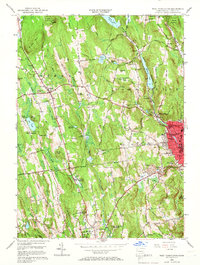
1956 Map of West Torrington
USGS Topo · Published 1966About this map
John Browns Birthplace (Ruins) sits among the hills of Torrington on this 1956 revision, marking a site of significant national historical importance. The map captures the transitional character of the mid-century landscape, where the industrial core of Torrington meets the educational and agricultural lands of Litchfield and Goshen. A dense concentration of specialized institutions is evident, including the Junior Republic Of Connecticut, the Litchfield School For Boys, and the St Louis De Montfort Seminary, suggesting an era when this region served as a major center for private education and social services. Hydrological management for the growing population is clearly visible through features like the Hart Reservoir, Whist Pond, and the Pumping Station near Pie Hill. From the Naugatuck River valley to the heights of Ivy Mtn State Park, the map documents a network of rural roads and emerging suburban clusters like Drakeville and Newberry Corner.
Find a feature on this map
80 named features on this map. Tap any name to fly to it.
Don’t see what you’re looking for? This feature index may not catch every label — zoom into the map to look around manually.
Map Details
Editions of this 1956 West Torrington Map
5 editions found

Other maps of this area

1892 · Winsted
USGS Topo · 1:62,500

1892 · Cornwall
USGS Topo · 1:62,500

1892 · New Milford
USGS Topo · 1:62,500

1893 · Waterbury
USGS Topo · 1:62,500

1893 · New Milford
USGS Topo · 1:62,500

1893 · Cornwall
USGS Topo · 1:62,500

1903 · Cornwall
USGS Topo · 1:62,500

1904 · New Milford
USGS Topo · 1:62,500

1904 · Waterbury
USGS Topo · 1:62,500

1904 · Litchfield
USGS Topo · 1:125,000