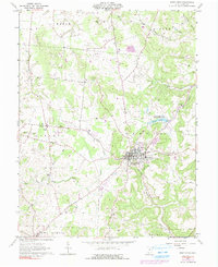
1961 Map of West Union
USGS Topo · Published 1991About this map
West Union serves as the focal point of this Adams County landscape, anchored by public institutions like the County Hospital, Childrens Home, and the County Fairgrounds. The town's layout is surrounded by the winding waters of East Fork Eagle Creek and Hannah Run, while to the northeast, the Adams Lake State Reserve provides a notable landmark of mid-century conservation. Cultural and social history is deeply etched into the countryside through numerous small cemeteries and churches, such as Chaparral Cem, Kirker Cem, and the Oak Grove Ch, which mark the intersections of rural roads. The 1974 photo-revisions (shown in purple) illustrate the transition of the era, capturing modern developments like the Drive-in Theater and Roadside Park alongside traditional landmarks like Nixon Chapel Cem. This survey illustrates the steady maturation of the county seat as it expanded while maintaining its traditional agricultural character across the townships of Liberty and Tiffin.
Find a feature on this map
34 named features on this map. Tap any name to fly to it.
Don’t see what you’re looking for? This feature index may not catch every label — zoom into the map to look around manually.
Map Details
Editions of this 1961 West Union Map
3 editions found
Other maps of this area

1916 · Peebles
USGS Topo · 1:62,500

1918 · Peebles
USGS Topo · 1:62,500

1918 · Seaman
USGS Topo · 1:62,500

1919 · Vanceburg
USGS Topo · 1:62,500

1929 · Springdale
USGS Topo · 1:48,000

1935 · Springdale
USGS Topo · 1:62,500

1949 · Vanceburg
USGS Topo · 1:62,500

1949 · Concord
USGS Topo · 1:24,000
1951 · Concord
USGS Topo · 1:24,000

1952 · Maysville East
USGS Topo · 1:24,000