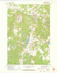
1970 Map of Westboro
USGS Topo · Published 1972About this map
The Soo Line corridor anchors this northern Wisconsin landscape, running north-south through the settlements of Westboro and Chelsea. This 1970 field-checked survey captures a transition in local infrastructure, where the active rail line operates alongside remnants of earlier logging or spur routes like the Old Railroad Grade near Wellington Lake. The western portion of the map is dominated by the Chequamegon National Forest, marked by the presence of a Lookout Tower and a dense network of glacial water bodies including Ketcham Lake and Mud Lake. Genealogy researchers will find several well-defined burial sites, including Mount Olive Cem west of Queenstown and the Chelsea Cems near the town center. The drainage of the Black River and Silver Creek further defines the terrain, showing a mix of established wetlands and active gravel extraction points scattered across the township lines.
Find a feature on this map
37 named features on this map. Tap any name to fly to it.
Don’t see what you’re looking for? This feature index may not catch every label — zoom into the map to look around manually.
Map Details
Editions of this 1970 Westboro Map
2 editions found
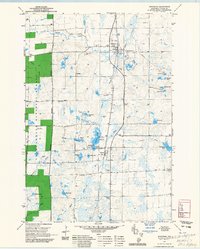
Other maps of this area

1902 · Marathon
USGS Topo · 1:125,000

1944 · Ogema
USGS Topo · 1:48,000

1945 · Rib Lake
USGS Topo · 1:48,000

1947 · Rib Lake
USGS Topo · 1:48,000

1947 · Ogema
USGS Topo · 1:48,000

1949 · Ogema
USGS Topo · 1:48,000

1949 · Rib Lake
USGS Topo · 1:48,000

1951 · Athens
USGS Topo · 1:48,000

1951 · Medford
USGS Topo · 1:48,000

1953 · Rice Lake
USGS Topo · 1:250,000