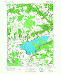
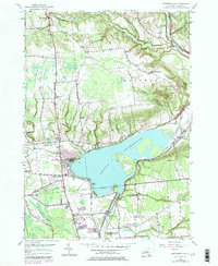
1955 Map of Westernville
USGS Topo · Published 1977About this map
The Delta Reservoir dominates the central landscape of this mid-century survey, its waters pooling north of the Rome city boundary and submerging portions of the Mohawk River valley. To the east, the village of Westernville sits near the confluence of the Lansing Kill, while the surrounding uplands like Quaker Hill and Stokes Hill are dotted with a dense network of local education and faith landmarks. Rural life in this era is evidenced by several district schools, including the Mullen Hill Sch and Lower Quaker Hill Sch, alongside the Evergreen Ch and Wells Cem. Large-scale land use is represented by the U S Military Res Jervis Test Site and the U S Mil Res Griffiss AFB on the southern edges, illustrating the significant federal footprint in Oneida County during the Cold War.
Find a feature on this map
58 named features on this map. Tap any name to fly to it.
Don’t see what you’re looking for? This feature index may not catch every label — zoom into the map to look around manually.
Map Details
Editions of this 1955 Westernville Map
5 editions found
Other maps of this area

1895 · Oriskany
USGS Topo · 1:62,500

1895 · Oneida
USGS Topo · 1:62,500

1898 · Oneida
USGS Topo · 1:62,500

1898 · Oriskany
USGS Topo · 1:62,500

1902 · Oneida
USGS Topo · 1:62,500

1904 · Boonville
USGS Topo · 1:62,500

1905 · Taberg
USGS Topo · 1:62,500

1939 · Oneida
USGS Topo · 1:62,500

1943 · Lee Center
USGS Topo · 1:31,680

1944 · Point Rock
USGS Topo · 1:31,680