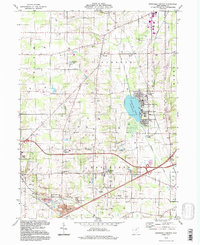
1994 Map of Westfield Center
USGS Topo · Published 1997About this map
Chippewa Lake serves as a central geographical focal point for this portion of Medina County, bordered by lakeside communities including Chippewa-on-the-Lake, Chippewa Lake Park, and Gloria Glens Park. The landscape is a characteristic mix of small-town centers and rural tracts defined by the Connecticut Western Reserve's land lines. The area's mid-century infrastructure and agricultural character are evident through numerous extractive sites like the Sand and Gravel Pits and various Gas Wells scattered across the Lafayette and Westfield townships.
Find a feature on this map
41 named features on this map. Tap any name to fly to it.
Don’t see what you’re looking for? This feature index may not catch every label — zoom into the map to look around manually.
Map Details
Editions of this 1994 Westfield Center Map
This is the sole edition of this map. No revisions or reprints were ever made.
Other maps of this area

1901 · Wooster
USGS Topo · 1:62,500

1903 · Wooster
USGS Topo · 1:62,500

1904 · Medina
USGS Topo · 1:62,500

1904 · Wellington
USGS Topo · 1:62,500

1906 · Medina
USGS Topo · 1:62,500

1906 · Wellington
USGS Topo · 1:62,500

1906 · West Salem
USGS Topo · 1:62,500

1908 · West Salem
USGS Topo · 1:62,500

1950 · Cleveland
USGS Topo · 1:250,000

1950 · Marion
USGS Topo · 1:250,000