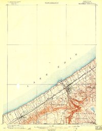
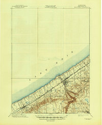
1899 Map of Westfield
USGS Topo · Published 1903About this map
Lake Erie defines the northern reaches of this Chautauqua County survey, where the shoreline and steep coastal escarpment dictate the movement of people and commerce. The industrial pulse of the late 19th century is evident in the dense concentration of rail infrastructure, including the Lake Shore and Michigan Southern R. R. and the New York Chicago and St Louis R. R., which run parallel to the coast. These lines connect coastal settlements like Barcelona and Westfield to the broader regional economy. Further inland, the terrain shifts into the dissected plateaus of The Gulf, where Chautauqua Creek carves a deep path through the township. The map records a series of small, rural hubs such as Volusia, Lombard, and Forsyth, alongside the Pennsylvania Boundary Line at the southwestern corner, illustrating the transition from lakefront transit to upland agriculture.
Find a feature on this map
21 named features on this map. Tap any name to fly to it.
Don’t see what you’re looking for? This feature index may not catch every label — zoom into the map to look around manually.
Map Details
Editions of this 1899 Westfield Map
6 editions found
Other maps of this area

1899 · Westfield
USGS Topo · 1:62,500

1900 · Dunkirk
USGS Topo · 1:62,500

1904 · Chautaqua
USGS Topo · 1:62,500

1905 · Clymer
USGS Topo · 1:62,500

1913 · North East
USGS Topo · 1:62,500

1915 · North East
USGS Topo · 1:62,500

1939 · Clymer
USGS Topo · 1:62,500

1941 · Chautauqua
USGS Topo · 1:62,500

1941 · Clymer
USGS Topo · 1:62,500

1943 · North East
USGS Topo · 1:62,500