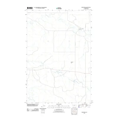
2011 Map of Westmore
USGS Topo · Published 2011About this map
The small settlement of Westmore sits in the northeastern corner of this Fallon County landscape, where the local transportation network is defined by Westmore Rd and Road 315. The terrain is characterized by a complex drainage system, with the meandering path of Sandstone Creek dominating the northern half of the quadrangle. Further south, the landscape is shaped by the presence of Hay Creek and the Ehret Land Reservoir Dam, indicating water management and land use patterns typical of this Montana prairie region. In the southwestern corner, the map captures the confluence of O'Fallon Creek and Pine Creek, illustrating the natural watercourses that define the local topography and have historically influenced land surveying and ranching boundaries in the area.
Find a feature on this map
8 named features on this map. Tap any name to fly to it.
Don’t see what you’re looking for? This feature index may not catch every label — zoom into the map to look around manually.
Map Details
Editions of this 2011 Westmore Map
This is the sole edition of this map. No revisions or reprints were ever made.
Other maps of this area

1953 · Miles City
USGS Topo · 1:250,000

1957 · Miles City
USGS Topo · 1:250,000

1958 · Miles City
USGS Topo · 1:250,000

1981 · Baker
USGS Topo · 1:100,000

1981 · Lawrence Creek West
USGS Topo · 1:24,000

1981 · Little Pine Creek
USGS Topo · 1:24,000
1981 · Ismay North
USGS Topo · 1:24,000

1981 · Bracket Butte SE
USGS Topo · 1:24,000

1981 · Ayer Spring
USGS Topo · 1:24,000
1981 · Plevna
USGS Topo · 1:24,000