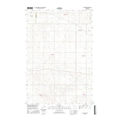
2017 Map of Westmore
USGS Topo · Published 2017About this map
Westmore sits as the central point of interest in this eastern Montana landscape where the transition between Custer and Fallon counties is documented. The terrain is defined by a dendritic drainage pattern where intermittent waterways like Sandstone Cr and Hay Cr carve through the prairie. In the southern reach, O'Fallon Cr and its tributary Pine Cr mark the low-lying areas of the quadrangle. The survey captures a local infrastructure network grounded in rural utility, with Westmore Rd and Yellowstone Rd providing primary access to the scattered sections. The presence of Cemetery Rd near the main settlement suggests a long-standing community focal point, essential for genealogists tracing early families of this high plains region.
Find a feature on this map
15 named features on this map. Tap any name to fly to it.
Don’t see what you’re looking for? This feature index may not catch every label — zoom into the map to look around manually.
Map Details
Editions of this 2017 Westmore Map
This is the sole edition of this map. No revisions or reprints were ever made.
Other maps of this area

1953 · Miles City
USGS Topo · 1:250,000

1957 · Miles City
USGS Topo · 1:250,000

1958 · Miles City
USGS Topo · 1:250,000

1981 · Baker
USGS Topo · 1:100,000

1981 · Lawrence Creek West
USGS Topo · 1:24,000

1981 · Little Pine Creek
USGS Topo · 1:24,000
1981 · Ismay North
USGS Topo · 1:24,000

1981 · Bracket Butte SE
USGS Topo · 1:24,000

1981 · Ayer Spring
USGS Topo · 1:24,000
1981 · Plevna
USGS Topo · 1:24,000