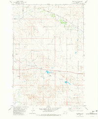
1981 Map of Westmore
USGS Topo · Published 1981About this map
The small settlement of Westmore sits along the Chicago Milwaukee St Paul and Pacific rail line, serving as a focal point in this eastern Montana landscape. The terrain is defined by the winding course of Sandstone Creek and its many tributaries, including Hay Creek and O'Fallon Creek. This 1981 edition shows a region heavily dependent on subterranean water sources, indicated by numerous scattered Flowing Wells, Springs, and designated water points. The crossing of the Custer Co Fallon Co boundary line marks the western edge of the quadrangle. Aside from the railroad and a single Gravel Pit, the map reveals a land structured by section lines and fence lines rather than dense settlement, reflecting the ranching and agricultural character of the era.
Find a feature on this map
12 named features on this map. Tap any name to fly to it.
Don’t see what you’re looking for? This feature index may not catch every label — zoom into the map to look around manually.
Map Details
Editions of this 1981 Westmore Map
This is the sole edition of this map. No revisions or reprints were ever made.
Other maps of this area

1953 · Miles City
USGS Topo · 1:250,000

1957 · Miles City
USGS Topo · 1:250,000

1958 · Miles City
USGS Topo · 1:250,000

1981 · Baker
USGS Topo · 1:100,000

1981 · Lawrence Creek West
USGS Topo · 1:24,000

1981 · Little Pine Creek
USGS Topo · 1:24,000
1981 · Ismay North
USGS Topo · 1:24,000

1981 · Bracket Butte SE
USGS Topo · 1:24,000

1981 · Ayer Spring
USGS Topo · 1:24,000
1981 · Plevna
USGS Topo · 1:24,000