1969 Map of Weston
USGS Topo · Published 1973About this map
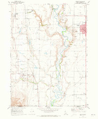
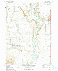
The Bear River winds through the heart of Franklin County, Idaho, defining a landscape shaped by early agricultural irrigation and the Union Pacific railroad corridor. In the late 1960s, the area's development is centered around Preston and Weston, where grid-patterned streets meet the industrial presence of a grain elevator and regional civic hubs like the Courthouse and City Hall. The map reveals a complex network of man-made waterways, including the West Cache Canal, East Cache Canal, and Twin Lakes Canal, which sustained the local farming economy.
Find a feature on this map
39 named features on this map. Tap any name to fly to it.
Don’t see what you’re looking for? This feature index may not catch every label — zoom into the map to look around manually.
Map Details
Editions of this 1969 Weston Map
2 editions found
Other maps of this area

1914 · Logan
USGS Topo · 1:125,000

1915 · Preston
USGS Topo · 1:96,000

1916 · Logan
USGS Topo · 1:125,000

1918 · Preston
USGS Topo · 1:125,000

1954 · Pocatello
USGS Topo · 1:250,000

1954 · Ogden
USGS Topo · 1:250,000

1954 · Brigham City
USGS Topo · 1:250,000

1955 · Preston
USGS Topo · 1:250,000

1958 · Ogden
USGS Topo · 1:250,000

1958 · Pocatello
USGS Topo · 1:250,000