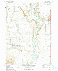
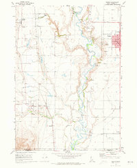
1969 Map of Weston
USGS Topo · Published 1991About this map
The Bear River winds through a complex irrigation landscape north of the Idaho-Utah border, where a network of gravity-fed water systems like the Twin Lakes Canal and West Cache Canal support the agricultural valleys of Franklin County. In Preston, the county seat is well-defined by its grid, featuring the Courthouse, City Hall, and the Municipal Airport to the west. The map highlights the region's reliance on agriculture and transit, from the Grain Elevator in Weston to the unusual Little Santa Anita Racetrack located between the river and the northern uplands. Local history is anchored by sites such as the Westside High Sch in Dayton and several instances of a Historical Monument, marking the heritage of these Mormon corridor settlements during the late 1960s. Smaller communities like Anderson and Fairview appear as distinct clusters along the southern roads, while numerous Springs and the Squaw Springs (Hot) indicate the geothermal activity common to the Bear River basin.
Find a feature on this map
32 named features on this map. Tap any name to fly to it.
Don’t see what you’re looking for? This feature index may not catch every label — zoom into the map to look around manually.
Map Details
Editions of this 1969 Weston Map
2 editions found
Other maps of this area

1914 · Logan
USGS Topo · 1:125,000

1915 · Preston
USGS Topo · 1:96,000

1916 · Logan
USGS Topo · 1:125,000

1918 · Preston
USGS Topo · 1:125,000

1954 · Pocatello
USGS Topo · 1:250,000

1954 · Ogden
USGS Topo · 1:250,000

1954 · Brigham City
USGS Topo · 1:250,000

1955 · Preston
USGS Topo · 1:250,000

1958 · Ogden
USGS Topo · 1:250,000

1958 · Pocatello
USGS Topo · 1:250,000