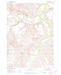
1951 Map of Westover
USGS Topo · Published 1977About this map
The White River and Little White River meet in this landscape of the Rosebud country, winding through the sharp breaks of Mullen and Westover. Based on 1949 photography and a 1951 field check with 1970s revisions, the map reveals the intricate drainage patterns of Horse Creek and Cottonwood Creek as they carve through the river bluffs. The small settlement of Westover sits near the northern river bend, while the isolated Riverview Sch serves the surrounding ranching community. The map also delineates the Reservation Boundary and the county line between Jones and Mellette Counties, providing a clear view of the rural infrastructure and land divisions that shaped this part of South Dakota in the mid-20th century.
Find a feature on this map
10 named features on this map. Tap any name to fly to it.
Don’t see what you’re looking for? This feature index may not catch every label — zoom into the map to look around manually.
Map Details
Editions of this 1951 Westover Map
3 editions found
Other maps of this area

1951 · Murdo SE
USGS Topo · 1:24,000

1951 · White River NE
USGS Topo · 1:24,000

1951 · Westover
USGS Topo · 1:24,000

1951 · Murdo SW
USGS Topo · 1:24,000

1951 · Murdo 3 NE
USGS Topo · 1:24,000

1951 · Okaton SE
USGS Topo · 1:24,000

1955 · Martin
USGS Topo · 1:250,000

1958 · Martin
USGS Topo · 1:250,000

1982 · White River SE
USGS Topo · 1:24,000

1982 · White River East
USGS Topo · 1:24,000