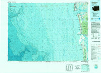
1989 Map of Westport
USGS Topo · Published 1989About this map
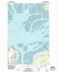
Grays Harbor serves as the central anchor for this late-twentieth-century study of the Washington coastline, where the convergence of marine and riverine systems is meticulously documented. The map details the complex bathymetry of the Pacific Ocean floor, specifically highlighting the dramatic drop-off at Guide Canyon. Along the shore, the shifting sands of the North Beach Peninsula and the protective barrier of Leadbetter Point illustrate the precarious balance of coastal geography.
Find a feature on this map
40 named features on this map. Tap any name to fly to it.
Don’t see what you’re looking for? This feature index may not catch every label — zoom into the map to look around manually.
Map Details
Editions of this 1989 Westport Map
This is the sole edition of this map. No revisions or reprints were ever made.
Historical Maps of Ocean Shores Through Time
7 maps found