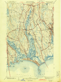
1942 Map of Westport
USGS Topo · Published 1942About this map
East Branch Westport River dominates this coastal landscape, carved into a complex network of points, flats, and islands just before World War II. The settlement pattern is defined by numerous crossroads like Handy Four Corners and Gidleys Corner, while the civic heart of the community is anchored at Central Village with its Town Hall and High Sch. To the south, the barrier beaches of Horseneck Beach and East Horseneck Beach protect Westport Harbor from the Atlantic. This era of the landscape features a distinct military presence at the National Guard Rifle Range near Russells Mills. Further inland, the geography transitions into the wooded wetlands of Deerfield Swamp and the headwaters at the Head of Westport, where the river narrows into smaller tributaries like Bread and Cheese Brook.
Find a feature on this map
87 named features on this map. Tap any name to fly to it.
Don’t see what you’re looking for? This feature index may not catch every label — zoom into the map to look around manually.
Map Details
Editions of this 1942 Westport Map
3 editions found
Other maps of this area

1885 · New Bedford
USGS Topo · 1:62,500

1885 · Sakonnet
USGS Topo · 1:62,500

1888 · New Bedford
USGS Topo · 1:62,500

1888 · Fall River
USGS Topo · 1:62,500

1888 · Sakonnet
USGS Topo · 1:62,500

1893 · Sakonnet
USGS Topo · 1:62,500

1893 · Fall River
USGS Topo · 1:62,500

1893 · New Bedford
USGS Topo · 1:62,500

1918 · New Bedford
USGS Topo · 1:62,500

1919 · Fall River
USGS Topo · 1:62,500