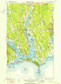
1951 Map of Westport
USGS Topo · Published 1951About this map
Head of Westport and the surrounding coastal villages define this landscape of tidal rivers and agricultural plateaus in the early 1950s. The map illustrates a community shaped by the East Branch Westport River and the West Branch Westport River, which converge at Westport Harbor. This era shows a mix of traditional New England settlement patterns and developing recreation, with the Westport Yacht Club and a Golf Course situated near the barrier beaches. Cultural landmarks like Central Village and the Town Hall serve as civic hubs, while dozens of family-named intersections such as Sissons Corner and Booth Corner reflect the area's deep-rooted genealogy. Along the Atlantic coast, the geography of Horseneck Beach and Gooseberry Neck remains largely undeveloped, featuring a Military Res and several named flats like Bailley Flat and Whites Flat visible at low tide.
Find a feature on this map
90 named features on this map. Tap any name to fly to it.
Don’t see what you’re looking for? This feature index may not catch every label — zoom into the map to look around manually.
Map Details
Editions of this 1951 Westport Map
3 editions found
Other maps of this area

1885 · New Bedford
USGS Topo · 1:62,500

1885 · Sakonnet
USGS Topo · 1:62,500

1888 · New Bedford
USGS Topo · 1:62,500

1888 · Fall River
USGS Topo · 1:62,500

1888 · Sakonnet
USGS Topo · 1:62,500

1893 · Sakonnet
USGS Topo · 1:62,500

1893 · Fall River
USGS Topo · 1:62,500

1893 · New Bedford
USGS Topo · 1:62,500

1918 · New Bedford
USGS Topo · 1:62,500

1919 · Fall River
USGS Topo · 1:62,500