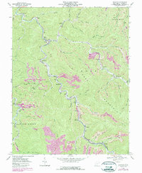
1968 Map of Wharton
USGS Topo · Published 1989About this map
Coal mining and river life define this West Virginia landscape along Pond Fork and its numerous tributaries. The map reveals a dense industrial and social network stretching from Bigson and Van in the north to Wharton and Barrett in the south. The narrow valley floors are tightly packed with evidence of the local extraction economy, including multiple Gas Wells, tipples, and tailings ponds tucked between the steep ridges of Crook Mountain.
Find a feature on this map
65 named features on this map. Tap any name to fly to it.
Don’t see what you’re looking for? This feature index may not catch every label — zoom into the map to look around manually.
Map Details
Editions of this 1968 Wharton Map
3 editions found
Other maps of this area

1891 · Oceana
USGS Topo · 1:125,000

1893 · Oceana
USGS Topo · 1:125,000

1898 · Oceana
USGS Topo · 1:125,000

1899 · Charleston
USGS Topo · 1:125,000

1909 · Peytona
USGS Topo · 1:48,000

1910 · Bald Knob
USGS Topo · 1:48,000

1911 · Peytona
USGS Topo · 1:62,500

1911 · Madison
USGS Topo · 1:62,500

1912 · Bald Knob
USGS Topo · 1:62,500

1913 · Logan
USGS Topo · 1:62,500